Recognize: What puts my family at risk?

How could flooding affect my home or property?

Learn about how flood follows risk and the different types of flooding.

Am I in a floodplain?

Focusing on flooding risk, the first question to ask is, "How do I know if I am in a floodplain?"

Enter your address to find your flood risk.

Learn whether your property is subject to flooding, with the Federal Emergency Management Agency (FEMA) Map Service Center provides maps to help you determine whether your property is in an area designated to have significant flood risk.

Where do I learn more about flood risks where I live?

In your community, local government is required to have a Local Floodplain Administrator that is supported by state, and federal agencies.

County Emergency Managers help prepare Emergency Action Plans to help prepare communities for potential flooding threats.

What types of hazards have been identified by my state?

The Montana State Hazard Mitigation Plan identifies recognizes hazards of many types throughout the state.
Section 3 can be used to identify your hazard types.

Don't dams and levees protect me from flooding?

Dams and levees do not eliminate flooding risk, they are constructed to capture and manage flood water to reduce damages caused by flooding.

Where can I learn more about the chances of flooding in my area?

Flooding doesn't just follow heavy rainfall.

When runoff from precipitation including rainfall and snow as well as snowmelt affects stream gages, the National Weather Service's Advanced Hydrologic Prediction Service provides current and historic infomation about flood stages at 259 sites througout Montana.

How can a frozen stream cause flooding?

Even with ice and snow on the surface, rivers and streams are still flowing. As temperatures fluctuate, ice can break up and create naural dams which cause localized flooding. Ice Jam flooding is characterized by rapildy increasing river stages that can be significantly higher than normal.


Is there a smartphone or tablet application where I can learn more?

The app will help you create a flood report with FEMA map information, your risks and approximate insurance costs using information from FEMA and the US Geological Survey.

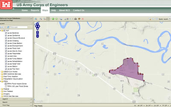
The USACE National Levee Database can be used to identify areas behind levee systems in the PL84-99 program.

National Levee Database

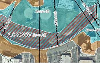
The FEMA Flood Map Service Center is the official public source for flood hazard information produced in support of the National Flood Insurance Program (NFIP). Use the map service center to find official flood maps, access other flood hazard products, and tools to better understand flood risk.

FEMA Map Service Center